
Drone Powerline Inspections in Manitoba: Safer Access, Better Documentation, Faster Decisions
A line crew and a drone pilot can look at the same insulator and reach the same conclusion. The difference is where they were standing when they did. One was on a structure or in a bucket. The other was on the ground, with a live view, a thermal reading, and a record that anyone on the team can open later.
Utilities across Manitoba manage long corridors that cross farmland, bush, and river crossings, and they do it through a climate that swings from spring thaw to deep winter. Inspection has to happen anyway. The question is how much risk, time, and inconsistency it costs. This article walks through how drone programs answer that question, what good documentation looks like, and why the operator matters as much as the aircraft. If you are already comparing aircraft, you can jump straight to the DJI Matrice 4 Series or the DJI Matrice 400, or browse all of our enterprise drones.
Why powerline inspection is risky and slow
Traditional inspection puts people close to the hazard. Crews climb structures, work from aerial lifts, or walk and drive the corridor to find problems by eye. Helicopter patrols cover ground quickly but bring their own cost and scheduling constraints. None of these methods is wrong. They are simply expensive in the two things utilities can least afford to spend: safety margin and time.
Height and energy
Working near energized conductors at height leaves little room for error, and every close approach needs planning and controls.
Distance and terrain
Right-of-way access can mean mud, snow, water, or no road at all. Reaching a structure can take longer than inspecting it.
Inconsistent records
Notes written by different people in different formats are hard to compare, so small defects are easy to miss between cycles.
The scale of the job is large. Manitoba Hydro's system alone includes over 11,000 kilometres of transmission lines, carrying both direct and alternating current at up to 500,000 volts. Add distribution feeders, substations, and rural lines, and the inspection workload is more than any crew can cover by climbing and walking alone.
How drones reduce the need to access difficult areas
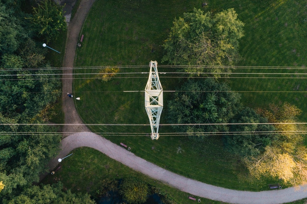
A drone flies the inspection from a standoff distance. Instead of sending someone up to check a connection, the pilot flies to it, zooms in, and looks at it from several angles while the crew stays on the ground. Zoom cameras read hardware detail that would otherwise need a climb. Thermal cameras show heat that no eye can see. Mapping flights capture the whole corridor in one pass.
The safest access is often no access. That does not remove line crews from the process. It changes what they do: they go to the structures that need attention, with the right tools, already knowing what they will find.
Manitoba utilities are already moving in this direction. Manitoba Hydro has used drones to install bird diverters on an energized transmission line near Delta Marsh, a first for the utility. Work near live conductors from the air is becoming normal practice.
Zoom, thermal, and mapping payloads
Three capabilities do most of the work in a utility inspection, and both the Matrice 4 Series and the Matrice 400 bring them together in one aircraft.
Zoom
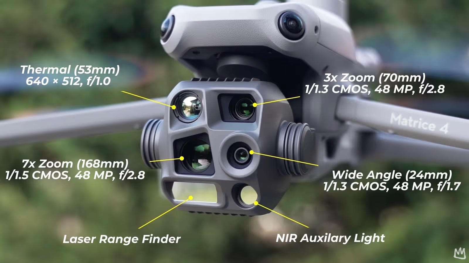
The Matrice 4 Series carries a 48MP telephoto camera with 168mm equivalent reach. Vantage lists it as able to pick out cracks and screws from about 10 m and keep 48MP clarity from 250 m.
Thermal
A 640×512 thermal camera with a high-resolution mode shows hot spots at connectors and splices. An NIR auxiliary light on the 4T supports low-light work.
Mapping and range
An 1800 m laser range finder measures distance and position from the air. For corridor models, the Matrice 400 also supports the Zenmuse L2 LiDAR and P1 payloads.
The Matrice 4T is the compact, quick-to-deploy option that Vantage positions for utilities, emergency response, and public safety. The Matrice 400 is the heavier platform for longer or more demanding work: up to 59 minutes of flight, a 6 kg payload capacity, IP55 weather protection, and operation from -20°C to 50°C, which suits prairie winters. It supports the Zenmuse H30 Series, which combines wide, zoom, thermal, laser range finder, and NIR light in one payload. It also detects wires and obstacles with LiDAR, radar, and fisheye sensors, and offers power line detection with AR and automated powerline tracking.
Those three are only part of the picture. Four more capabilities decide whether the data is actually usable on a real Manitoba day, when it is hazy, cold, dim, or crowded with wires.
Wide-angle and AI detection
A wide camera sets the scene: structure lean, right-of-way condition, and vegetation close to the line. On the Matrice 4 Series, AI object detection can flag vehicles, people, and boats, which helps when a corridor crosses roads or water.
Dehaze and anti-fog
Prairie haze, wildfire smoke, and cold mornings flatten a visible image. The Matrice 4 Series has electronic dehazing with three levels, and the Matrice 400 has built-in anti-fog. Both help keep detail readable when conditions are marginal.
Low light, NIR, and spotlight
Dusk and dawn are often when utilities can fly. The Matrice 4T adds full-color night modes and NIR lighting for up to 100 m of visibility, and the Matrice 400 can carry the Zenmuse S1 spotlight for night work.
Wire and obstacle sensing
Thin wires are the hardest thing to see from the air. The Matrice 400 combines LiDAR, radar, and low-light fisheye sensors to detect wires even in the dark or fog, and shows power lines with AR on screen. The 4 Series adds low-light fisheye vision for safer returns.
Here is how those sensors map to what inspectors actually look for.
| Looking for | Best sensor | What good evidence looks like |
|---|---|---|
| Hot connectors, clamps, splices | Thermal | A thermal and visible pair of the same component, with conditions noted |
| Cracked or contaminated insulators | Zoom | A sharp close-up from a consistent angle, tagged to the structure |
| Corrosion, loose or missing hardware | Zoom and wide-angle | A close-up plus a wide shot showing where it sits on the structure |
| Vegetation and clearance | Wide-angle and laser range finder | A measured distance to the conductor, with location |
| Hazy or smoky days | Dehaze, zoom, thermal | Readable visible imagery, backed by thermal where it helps |
| After-hours or outage checks | Thermal, NIR, spotlight | Time-stamped imagery captured under safe lighting |
One honest caution: thermal readings depend on distance, humidity, wind, and how much load the line is carrying, and dehazing improves the visible image without changing the physics of the scene. That is why good inspections record the conditions alongside every finding, and why trained operators matter.
What good inspection documentation looks like
A photo of a tower is not an inspection record. A record has to answer, months later and for someone who was not there, three questions: what was checked, what was found, and how does it compare to last time. Good documentation follows a simple sequence on every structure.
- Identify the assetEvery structure and component gets the same ID in every flight, matching the utility's own asset register.
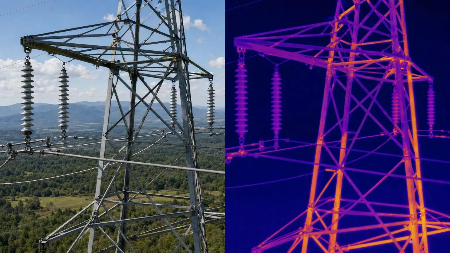
- Capture paired visual and thermal imagesThe RGB image shows what it is. The thermal image shows how it is behaving. Together they make a finding defensible.
- Tag location and distancePositioning data and range measurements let a crew find the exact component without a second patrol.
- Classify the findingA consistent scale, such as no action, monitor, or schedule repair, turns images into decisions.
- Save it as a baselineNext cycle, the same viewpoint is captured again, so change over time is visible instead of guessed.
Tools help here too. The Matrice 400 supports a Cloud API through DJI Pilot 2, so imagery and flight data can feed a utility's own systems, and the Matrice 4 Series produces automatic survey reports after mapping flights.
Why repeatable workflows and trained operators matter
Hardware captures the data. A repeatable workflow makes it useful. When each pilot flies the same standoff distances, uses the same camera settings, and names files the same way, comparisons between cycles are trustworthy and reports need less cleanup. That consistency comes from training and written procedures, not from the aircraft.
It also comes from judgment. Long corridors bring wind, cold-weather battery management, airspace, and in many cases operations that go beyond visual line of sight, so requirements should be confirmed against Transport Canada rules for the specific mission. This is the gap Vantage Drone School is built to close. Training moves from knowledge (regulations, weather, airspace, and mission planning) into practice and simulation, then into supervised live field training, so pilots build habits before they take higher-value aircraft into demanding work.
The school runs in person in Carman, Manitoba, and can train whole teams, including municipalities and public works groups. Current courses include the A1-102 Advanced Operations Certificate Bundle and the A1-103 Level 1 Complex / BVLOS Certification, which is available by inquiry. Vantage also stays available after training for equipment questions, refreshers, and first-mission planning.
Choosing the right platform
| Matrice 4T | Matrice 400 | |
|---|---|---|
| Role | Compact, fast-deploy inspection aircraft | Heavy-duty platform for long or demanding missions |
| Imaging | Wide, medium tele, and 48MP telephoto with laser range finder | Zenmuse H30 Series, plus L2 LiDAR, P1, and other payloads |
| Thermal | 640×512 with high-res mode and NIR light | Integrated in the H30 Series |
| Endurance and weather | Built for routine, fast-turnaround flights | Up to 59 min, IP55, -20°C to 50°C |
| Best fit | Utilities that need quick, frequent inspections | Corridor programs that need range, payload options, and wire awareness |
Many utilities end up with both: a compact aircraft for everyday checks and a Matrice 400 for the jobs that need range and payload flexibility. A short demo with your own asset types is the fastest way to see which fits. Already flying a Matrice 350 RTK? The Zenmuse H30 Series payloads work on it too.
Gear up for the field
A capable aircraft needs a capable support kit. For the Matrice 400, Vantage carries enterprise accessories including the TB100 batteries, BS100 intelligent battery station, DJI RC Plus 2 Enterprise Enhanced controller, DJI Cellular Dongle 2, and D-RTK 3 station, all available through the accessories shop. Payloads such as the H30 Series, L2, and S1 spotlight are listed on the Matrice 400 payloads page. Coverage is available through DJI Care Enterprise, and financing options can help spread the cost of a fleet. Prices are quoted on request, so get in touch for a package built around your inspection program.
See it on your own assets
Book an enterprise demo with the Vantage team. We will match the aircraft, payloads, and training to your inspection program.
Book an enterprise demoExplore Drone School